2015年8月7日,美國環境數據監控軟體公司 Groundswell Technologies, Inc.,於美國加州中區聯邦地方法院西分院(United States District Court,Central District of California, Western Division)控告美國數據中心節能方案公司 SynapSense Corporation,及其母集團公司 Panduit Corporation侵犯其 US6,915,211專利(下稱 ’211號專利)之專利權。
本案爭議專利 ‘211號名稱「地理資訊之即時監控暨回報系統(GIS based real-time monitoring and reporting system)」,申請日 2003年4月4日,獲證日 2005年7月5日,並援引二件美國臨時申請案 No.60/370,304(優先權日為 2002年4月5日)及 No.60/424,641(優先權日為 2002年11月6日)。
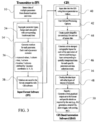
系爭專利 ‘211號共計有20個申請專利範圍請求項,其中有4個獨立項。其獨立項之技術特徵略為,首先利用「即時場域資訊感知單元 (real-time field data sensor 10)」蒐集「即時環境資訊(real-time data)」,再將該些即時環境資訊轉換成「基本矩陣(cardinal matrix form)」,又利用該基本矩陣產生「地理資訊系統之兼容資訊(GIS compatible data)」,進而以該地理資訊系統之兼容資訊進行地理統計分析並製圖,進而完成地理資訊監控的即時圖像之繪圖與顯示。
另參考美國專利商標局公開資訊網(US PAIR)之專利申請紀錄,審查委員認為 US6,753,74,US6,429,812,US5,689,418,US5,666,648,及 US5,470,233此五件美國專利已揭露 ‘211號專利大部份的技術內容。然而 ‘211號專利與該些引證案之差異(專利性)有二。第一,係依據感知單元自動地監控即時事件而生(a cardinal matrix form corresponding to a simultaneous automated monitoring event for the sensor packages)。第二,依據地理統計分析產生製圖外觀(conducting geostatistical analysis to generate a cartographic layout)。
原告 Groundswell 係一間註冊於美國德拉瓦州的環境監測軟體公司,主要業務在於利用環境數據感知單元及網頁操作介面,提供視覺化的即時環境監測整合式服務,並與數個數據中心建立合作夥伴關係。
被告 SynapSense 係一間註冊於美國德拉瓦州的節能方案提供商,成立於 2006年,主要業務在於利用無線感知網路架構,發展環境監控及節能解決方案。2014年,與其同領域的節能解決方案大型公司 Paduit 將 SynapSense 併入其下。
原告 Groundswell 於起訴狀陳稱,被告 SynapSense 的 LiveImaging system 產品,以環境感知單擷取並轉換環境數據,進而達成即時的環境監測及報告,顯已侵犯其 ‘211號專利之專利權。兩造雖於起訴前已進行多次接觸,試圖以談判授權之方式解決爭端,惟因被告反悔而未能成功。故請求法院判決確認被告侵權,要求被告停止損害,並賠償原告之損失。(1156字;表3)
表一、訴訟案件基本資料
| 訴訟名稱 |
Groundswell Technologies, Inc. v. Synapsense Corporation et al |
| 提告日期 |
2015年8月7日 |
| 原告 |
Groundswll Technologies, Inc. |
| 被告 |
Panduit Corporation
Synapsense Corporation |
| 案號 |
2:15-cv-06024 |
| 法院 |
加州中區聯邦地方法院西分院
District Court,Central District of California, Western Division |
| 爭議專利 |
US 6,915,211 |
| 爭議產品 |
LiveImaging system |
| 訴狀下載 |
 |
表二、爭議專利資訊
| 專利名稱 |
GIS based real-time monitoring and reporting system |
| 公告號 |
US 6,915,211 |
| 申請號 |
10/407,926 |
| 申請日 |
2003年4月4日 |
| 優先權 |
2002年4月5日 |
| 獲證日 |
2005年7月5日 |
| 專利權人 |
Groundswell Technologies, Inc. |
| 代表圖示 |
 |
表三、申請專利範圍第一項解析
| US 6,915,211 Claim9 |
| 9. A method for real-time monitoring and reporting of environmental parameters comprising the steps of: |
installing a plurality of sensor packages;
安裝複數個感應器封裝; |
transmitting data from the sensor packages;
自感應器封裝傳遞數據; |
receiving the transmitted data;
接收該傳遞數據 |
manipulating the data into a cardinal matrix format corresponding to a simultaneous automated monitoring tin event for the sensor packages;
依據由該些感應器封裝即時自動監控之事件,操作(處理)該數據,以產生一基本矩陣 |
triggering processing of the matrix formatted data;
觸發該基本矩陣格式數據之處理程序 |
conducting real time geostatistical analysis on the matrix formatted data;
於該矩陣格式數據之上,建立即時地理統計分析 |
creating GIS compatible data from the geostatistical analysis;
自該地理統計分析,建立地理資訊系統(GIS, geographical information system)之兼容數據; |
generating a cartographic layout from the GIS compatible data;
自該地理資訊系統之兼容數據,產生一製圖佈局; |
overlaying cartographic layouts as layers for display; and
覆蓋製圖佈局為圖層顯示;和 |
reporting the overlayed cartographic layouts.
回報重疊的製圖佈局。 |
本網站相關連結:
--------------------------------------------------------------------------------------------------------------------------------------------